
| |||||
|
|
|
|
|
|
|
|
|
|
|
|
|
|
Three Hurricanes Threaten the U.S.
W. Timothy Liu, NASA Jet Propulsion Laboratory
The radar scatterometer SeaWinds on the NASA Mission QuikSCAT observes three hurricanes threatening both the east and west coasts of the United States at the same time. In the figure, white streamlines indicating wind direction are superimposed on the color image of wind speeds. The wind vectors derived from SeaWinds observations are objectively interpolated to give a synoptic view at midnight of Greenwich Mean Time. Tropical Storm Hilary, which appears southwest of Baja California in the image, was borne in the warm water of the eastern tropical Pacific and is moving north. Tropical Storm Harvey was borne in the Gulf of Mexico, and is moving towards Florida. Hurricane Gert , which in full force, has moved closer to the U.S. from the tropical Atlantic.
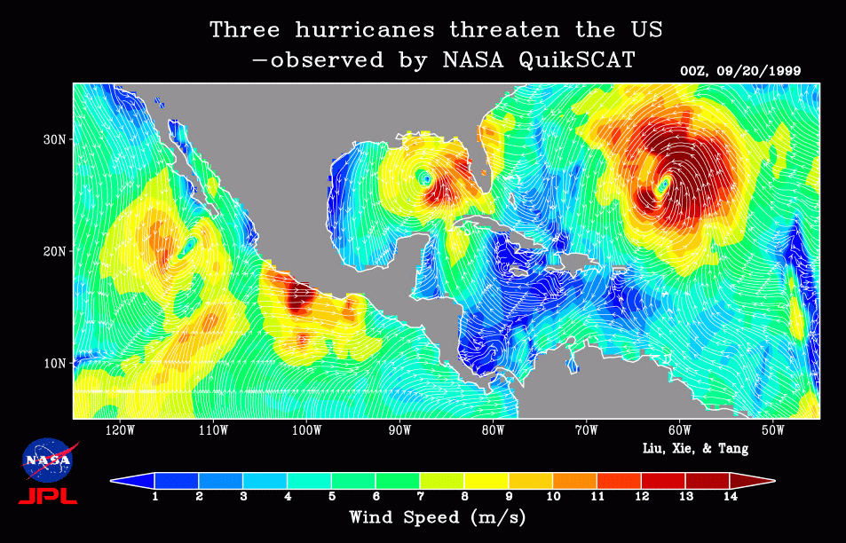
Over the ocean, in situ observations in a tropical cyclone are extremely sparse, and conventional satellite data only provide cloud image at the top of the storm. Weather satellite, despite their frequent coverage, can only view part of the world's ocean. SeaWinds, in contrast, provides daily coverage of over 93% of the global ocean under both clear and cloudy conditions, and, therefore, can monitor all the tropical storms in the world's ocean at the same time. Its 25-km spatial resolution gives sufficient details of wind field around tropical cyclones.
Xiaosu Xie made the color picture.
| PRIVACY | | IMAGE POLICY |
Webmaster: Xiaosu Xie
|