
| |||||
|
|
|
|
|
|
|
|
|
|
|
|
|
|
Hurricane Floyd
W. Timothy Liu, NASA Jet Propulsion Laboratory
In situ observations over the ocean are extremely sparse during a hurricane, and conventional satellite data only provide cloud imagery at the top of the storm. Hurricanes are devastating when they are accompanied by strong winds and heavy rain. Two new satellite missions, QuikSCAT and the Tropical Rain Measuring Mission (TRMM), provide the opportunity to observe both wind and rain in hurricanes prior to land-fall. The coincident measurements of surface wind and rain reveal the interplay between the dynamics and the hydrologic processes of the storms. When applied to Hurricane Floyd, the high spatial resolution of ocean surface winds measured by QuikSCAT improves computation of the moisture transport, the vertical profiles of moisture sink and diabatic heating, and the difference between evaporation and rain-rate at the surface. The results were validated by the observations of surface rain and rain profiles by the TRMM.
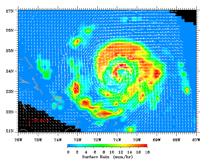
The close relationship between the dynamic and hydrologic parameters is visible
in Figure 1
as Hurricane Floyd approaches the Bahamas on September 13, 1999.
Surface winds feed
moisture into the hurricane. The moisture turns into rain, releases latent heat,
and fuels the
storm. After the image in Figure 1 was taken, Hurricane Floyd turned north. Its
strength and
proximity to the Atlantic coast caused the largest evacuation of
citizens in U.S. history.
Landfall of Hurricane Floyd on September 16 resulted in severe
flooding and devastation in the Carolinas.
SeaWinds provides a continuous 1800-km swath, thus providing over 92% coverage of the global ocean daily. The standard wind products have a 25-km resolution, but the data used in this study are produced to have a space resolution of 12.5 km. This is significant improvement over previous scatterometers in monitoring hurricanes. The NASA Scatterometer (NSCAT), which failed in 1997, had a wide nadir-gap between two 600-km swaths, one on each side of the spacecraft, and a spatial resolution of 25 km; the data gap may prevent full coverage of a hurricane. The scatterometers of European Remote Sensing (ERS) satellites, which have been operating since 1992, have only a single 479-km swath and a spatial resolution of 50 km. ERS scatterometers cover only 40% of the global ocean daily and may miss large portions of hurricanes.
The image is part of the paper by Liu, W.T., H. Hu, and S. Yueh, 2000: Interplay between wind and rain observed in Hurricane Floyd. Eos, Trans. of AGU, Vol. 81, No. 23, pages 253, 257. (PDF file)
| PRIVACY | | IMAGE POLICY |
Webmaster: Xiaosu Xie
|