
| |||||
|
|
|
|
|
|
|
|
|
|
|
|
|
|
Hawaiian Wake
W. Timothy Liu, NASA Jet Propulsion Laboratory
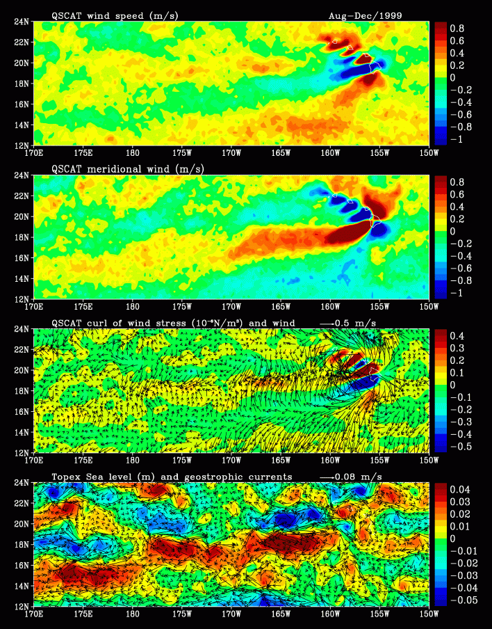
The subtropical Pacific should be monotonous. The Trade Winds blow steadily from east to west, and so flows the North Equatorial Current. Only the Hawaii Islands break this steady flow. According to conventional theories and observations, the wind wakes caused by the islands should dissipate within 300 km downstream, and should not be felt in the western Pacific. By sacrificing temporal resolution for high spatial sampling, the wind wake, consisting of low winds behind the islands and the strong winds through the gaps, are clearly visible in QuikSCAT data, within 300 km west of the islands. The fine resolution of QuikSCAT also reveals a persistent wind pattern to the west, composed of alternate high and low winds streaks, and lines of positive and negative curl of wind stress. This pattern stretches at least 3,000 km from the western side of the Hawaii Islands to beyond Wake Island in the western Pacific. The operational global NWP products (100-km spatial resolution) cannot resolve the mechanical wakes around the Hawaii Islands, and the 'long wake' far to the west has never been clearly identified in NWP winds. Wind stress curl usually creates higher and lower sea levels and geostrophic currents in the ocean.
The altimeter of Topex/Poseidon shows bands of positive and negative sea level changes, implying cyclonic and anticyclonic current gyres with an eastward geostrophic current between them at 19° N; the current should be continuous f rom western Pacific to the Hawaiian Islands. The microwave imager on the Tropical Rain Measuring Mission (TMI) data reveal a narrow band of warmer water and enhanced atmospheric convection (high cloud water) at the position of the geostrophic current, probably resulted from heat advection from the west. QuikSCAT also observes surface wind convergence and vorticity associated with the warm water and convection. The "long wake" revealed by QuikSCAT may be sustained by positive feedback between the ocean and the atmosphere. This narrow gap amidst westward flowing wind and current that may have aided the ancient eastward migration of Polynesian across half of the Pacific has never been viewed a single system until now.
Xiaosu Xie produced the color image.
Detailed discussion can be found in :
Liu, W.T., 2001: Wind over troubled water. Backscatter, Vol 12, No. 2, 10-14.
Xie, S.P., W. T. Liu, and Q. Liu, and M. Nonaka, 2000:
Far-reaching effects of the
Hawaiian Island on the Pacific Ocean-Atmosphere. Science, June 15.
| PRIVACY | | IMAGE POLICY |
Webmaster: Xiaosu Xie
|