ANTARCTIC WIND-ICE INTERACTION
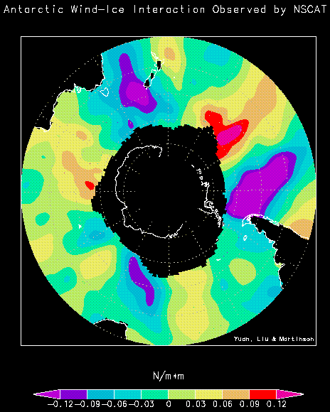
This figure shows the distribution of the meridional (north-south) component of
surface-wind stress observed by NSCAT aroud Antarctica, during a perion of maximum sea ice in September
1996. Land massess are outlined in white; areas outside the white lines are covered by sea-ice.
The sea-ice edge (SIE) shows three ice-extent maxima located in the central Indian Ocean
(near the left side), east of the Ross Sea (towards top right), and in the eastern Weddell Sea
(towards bottom). A relatively stable "wave number 3" atmospheric circulation prevails in the Southern Ocean,
which implies that the mean atmospheric circulation influences the sea-ice distribution.
The ice-extent maxima can enhance the meridional
thermal gradient and, therefore, strengthen the westly winds north of the SIE.
A thermal gradient enhancing the local
southerlies results from the decreasing ice extent east of the ice maxima. This
interplay between the mean atmospheric circulation and ice distribution causes the eastward
propagation of the ice maxima. Most of the strong and long-lasting storms in the
Southern Oceans have been observed to initiate from the two ice maxima in the Indian
Ocean and Ross sea. [From Yuan, X., D. G. Martinson, and W. T. Liu, 1999:
The effect of air-sea-ice interaction on winter 1996 southern ocean subpolar storm
distribution. J. Geophys. Res. - Atmosphere, 104, 1991-2007].