[From Liu, W.T., and W. Tang, 1997: Spaceborne scattterometer in studies of
atmospheric and oceanic phenomena from synoptic to interannual time scales.
In Space Remotre Sensing of Subtropical Ocean., C.T. Liu (ed.), Elsevier
Press, Amsterdam.]
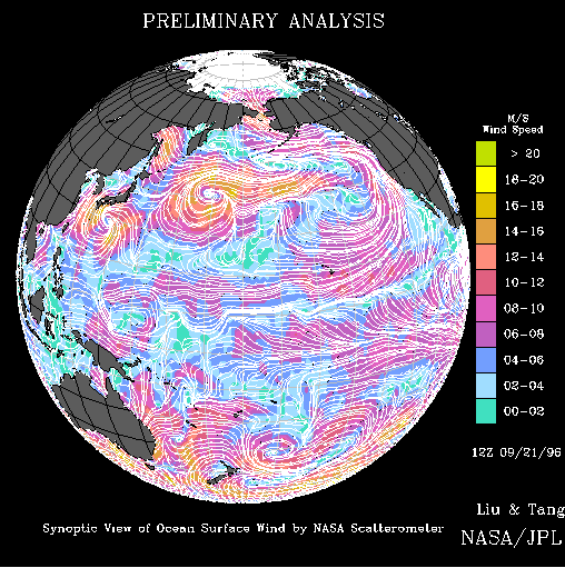
This image shows ocean surface wind speeds and directions over the Pacific
Ocean on 21 September 1996, 12 UTC, derived from observations by the NASA
Scatterometer (NSCAT) onboard Japan's Advanced Earth Observing Satellite
(ADEOS). The background color indicates wind speed and the white arrows
show the direction of the wind. The basin-wide wind field is typical of
near-Equinox atmospheric circulation. The strong (red color)Trade Winds
blow steadily from the cooler subtropical ocean to the warm water of the
Intertropical Convergence Zone (ITCZ) located just north the Equator.
Instead of blowing in the north-south direction, the winds are deflected
westward by the Corriolis Force due to the Earth's rotation. The air rises
over the warm water of ITCZ and sinks in the subtropics at the Horse
Latitudes, forming the Hadley Circulation. Both the convergence area at
the ITCZ and the divergence area at the Horse Latitudes are indicated by
low wind speed of blue color. In the mid-latitudes, the high vorticity due
to strong Corriolis Force generates cyclones (yellow spirals) moving in the
eastward direction. Two typhoons are observed in the western Pacific.
Typhoon Violet is just south of Japan. After these data were taken,
Typhoon Violet struck the East Coast of Japan causing damage and deaths.
Typhoon Tom is located further east and did not land.
The image is based on preliminary processing of the first set of NSCAT
observations, using prelaunch model function and calibration. The NSCAT
data is objectively interpolated into 12 hourly and 1 degree longitude by
1 degree latitude grids, using the methodology described by Tang and Liu [JPL
Publication 96-19, 1996], but with no other data used for initialization.
This preliminary analysis clearly demonstrates that the high spatial
resolution of NSCAT and its observing capability under cloudy conditions
improve the monitoring of sever storms, such as typhoon, whose location and
intensity are usually not well-defined by conventional methods. It also
shows that the repeated global coverage provides a better description of
atmospheric circulation over ocean, which has not been adequately sampled
in the past.