
|
|
QuikSCAT winds
Seaflux provides, at near-real-time, twice-daily maps of ocean surface winds over global oceans, derived from the observations by the scatterometer SeaWinds on space mission QuikSCAT, of the National Aeronautics and Space Administration (NASA). From these maps, emerging marine weather systems can be monitored. Improved scientific products will be available in delayed mode.
 Quikscat wind streamlines for Pacific, Atlantic, and Indian Oceans
|
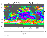 Quikscat wind zonal, meridional components and wind speed over global ocean surface
|