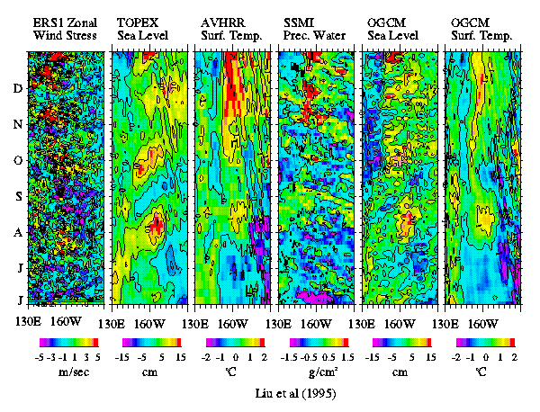
A recent anomalous warming event in the tropical Pacific consists of a series of intraseanal episodes, observations from four spaceborne sensors and simulation by an ocean general circulation model show. The figure includes time-longitude variations, along the equator, of the 1994-1993 difference in (a) zonal wind component, (b) sea level, (c) sea surface temperature, and (d) atmospheric water-vapor, as derived from spacebased observations and corresponding simulation of sea level (e) and sea surface temperature (f) by the Modular Ocean Model developed at the Geophysical =46luid Dynamics Laboratory when forced by realistic wind. The vertical axis represents time in months; the horizontal axis represents longitude, running from Indonesia, across the Pacific, to the Galapagos Islands. The zonal wind component is derived from observations by the microwave scatterometer on the European spacecraft ERS-1. The sea-surface height is derived from the observations by the microwave altimeter on the joint U.S.-French Topex/Poseidon Mission. The sea-surface temperature is produced through optimal interpolation of data from the Advanced Very High Resolution Radiometer blended with in situ data. The atmospheric integrated water vapor is derived from observations by the Special Sensor Microwave Imager.
Along the equator, the Trade Wind usually blows from east to west and should be negative, following our convention. Four distinct groups of equatorial westerly (positive) wind anomalies near the date line were observed by the scatterometer from July through December 1994. The wind anomalies initiated eastward-propagating, downwelling Kelvin waves. These waves, in turn, caused a rise in sea-level that was registered by the altimeter. Surface-warming episodes related to the Kelvin waves were observed by a visible-infrared radiometer. Anomalous integrated water vapor observed by the microwave radiometer indicate that the westerly wind and warming episodes are also associated with enhanced atmospheric convection. The observed variations in sea level and sea surface temperature anomalies agree with simulation by an ocean general circulation model when forced by realistic winds, both in time and location but with slightly different magnitudes.
Unlike the El Niño events of the 1980s, equatorial warming events in the 1990s are more frequent, last for shorter periods, and are less intense. Whether the 1994 warming can be classified as an El Niño is being debated. The realistic simulation provides a theoretic link between the observed forcing and responses and will help to further our understanding in the interaction between the episodic changes associated with Kelvin waves and the low-frequency changes of El Niño. The NASA Scatterometer (NSCAT) Project which is scheduled to be launched in August 1996 will provide improved wind field.