Monsoon Wind and Flood Index
W. Timothy Liu, NASA Jet Propulsion Laboratory
Three-day average vector winds over ocean and flood indexes over land derived from observations by SeaWinds on QuikSCAT, for four consecutive months in 1999 are shown. Topographic map for areas over 50-m elevation is plotted over flood indexes. Scatterometers are capable of monitoring not only the ocean winds, which feed moisture, but the consequent flooding of the land.
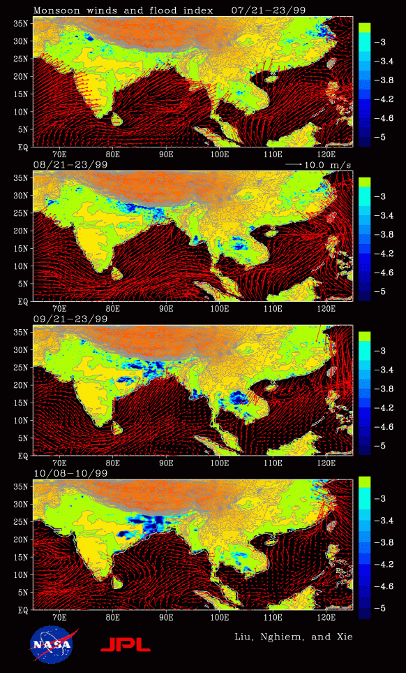 SeaWinds was launched just in time to observe extensive floods
in Asia caused by strong monsoons and tropical cyclones. The maps
show that the flooding in the Yangtze Valley of
China (30 N), represented by blue patches, is clearly visible
in July, following strong summer monsoons. The flooding
recedes in September, with the retreat of the summer monsoon and
the advance of the winter monsoon. The intensity of the flooding
increases again in October, after the landfall of a typhoon.
The flood in Bangladesh and east India did not start until
August but continues to strengthen through October. The most
severe floods in Vietnam, Thailand, and Burma occurred
in August and September, at the peak of summer monsoons.
SeaWinds was launched just in time to observe extensive floods
in Asia caused by strong monsoons and tropical cyclones. The maps
show that the flooding in the Yangtze Valley of
China (30 N), represented by blue patches, is clearly visible
in July, following strong summer monsoons. The flooding
recedes in September, with the retreat of the summer monsoon and
the advance of the winter monsoon. The intensity of the flooding
increases again in October, after the landfall of a typhoon.
The flood in Bangladesh and east India did not start until
August but continues to strengthen through October. The most
severe floods in Vietnam, Thailand, and Burma occurred
in August and September, at the peak of summer monsoons.
Both scattering and reflection from the surface contribute to the backscatter energy received by the scatterometer. Over dry land, scattering dominates and the horizontal polarization return (H) is smaller than the vertical polarization return (V). When the land gets flooded, however, the reflectivity of the surface increases greatly, and H becomes larger than V. The difference between reflectivities in H and V increases with incident angle, up to 80 degree. NSCAT measured H and V at incident angles varying from 10 to 59 degrees; it is difficult to collect H and V pairs at fixed incident angles. SeaWinds measures at fixed incident angles, H at 46 degree and V at 54 degree, with a large difference in reflectivity. The SeaWinds observations, therefore, are more conducive to monitor flooding than NSCAT. The continuous wide swath of QuikSCAT also is superior to NSCAT in covering flooding extent.
This figure and more detailed discussion can be found in the paper by Liu, W.T., X. Xie, W. Tang, and S.V. Nghiem, 2002: Wind Changes over the Western Pacific. East Asia and Western Pacific Meteorology and Climate, Vol. 1, 27-37, C.P. Chang (ed.) World Scientific Publishing Co., London. The uniformly gridded and objectively interpolated wind fields can be accessed through the Seaflux website.