Numerical Simulation of Coastal Oceanic Response to Typhoon Forcing
Error propagation from winds to ocean models was numerically investigated using
the Princeton Ocean Model (POM) for the South China Sea with 20-km horizontal
resolution and 23 sigma levels conforming to a realistic bottom topography during the
lifetime of tropical cyclone Ernie (November 4-18, 1996). Numerical integration was
divided into preexperimental and experimental stges. The preexperiment phase generates the initial
conditions on November 1 for the sensitivity experiment. During the experimental stage the POM
was integrated from November 1 to 30, 1996 under National Centers for Environmental Prediction (NCEP)
reanalyzed surface fluxes along with two surface wind data sets, namely, the daily averaged interpolated
NASA scatterometer winds and the NCEP winds. The relative root-mean-square differences fluctuate from 0.5
to 1.0 for winds, 0.25 to 0.7 for surface elevations, 0.47 to 1.02 for surface currents, and
0 to 0.23 for surface temperatures. This indicates that the model has less uncertainty overall
than the wind fields used to drive it, which in turn suggests that the ocean modeling community
may progress without waiting for the atmospheric modelers to build the perfact forecast model.
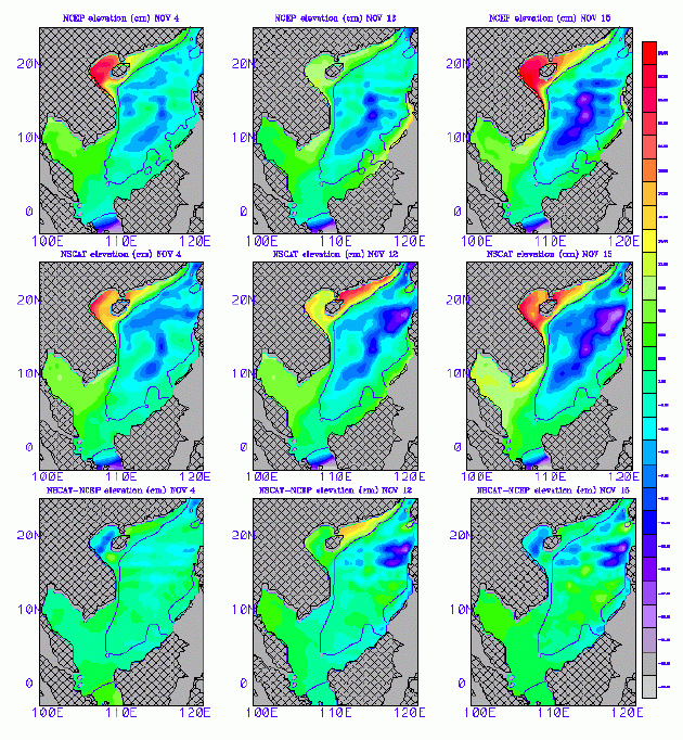
Caption:
The sea level in South China Sea simulated by an ocean general circulation
model during the passage of Typhoon
Ernie, when forced by winds from NSCAT and from operational numerical weather prediction (NWP) products
of NCEP are compared in the figure. Scatterometer winds generate more realistic ocean responses (sea surface
temperature, ocean current, and sea level changes) than winds from NWP.
Dr. Chu is developing methodology to examine the impact of high
resolution coastal winds (see Section on Data System) on Navy's
operational Shallow Water Analysis and Forecast System (SWAFS) which
was developed from POM.
Reference:
Chu, P.C., S. Lu, W.T. Liu, 1999: Uncertainty of the South China Sea
prediction using NSCAT and NCEP winds during tropical storm Ernie
1996, J. Geophys. Res., 104,11,273-11,289.
Chu, P., J.M. Veneziano, C. Fan, M.J. Carron, W.T. Liu, 2000: Response
of the South China Sea to tropical cyclone Ernie 1996. J. Geophys. Res.,
105, 13,991-14,009.
|