skip navigation JPL Home Page JPL Home Page - Earth JPL Home Page - Solar System JPL Home Page - Stars and Galaxies JPL Home Page - Science & Technology JPL Home Page - JPL Email News JPL Home Page - RSS JPL Home Page - Podcast JPL Home Page - Video NASA Home Page JPL Home Page CALTECH Home Page JPL AIR-SEA Home Page
JPL global navigation bar
  Sciences   Programs   Seaflux   People   El Niño   Links
  Press Release   Publications   Data   Objectives   Coastal   Contact
ATMOS. DISTURBANCES
Catalina Eddy
Lee Waves
Mountain Jets
Santa Ana winds

HURRICANE LANDFALL
Biological Responses
Ocean Model Simulation
Atmos. Model Simulation

S. CALIFORNIA BIGHT
Ocean Eddies
Pollution Hazards

ECOLOGY OF BOUNDARY CURRENT

THEORY AND MODEL
Upwelling Dynamics
Model Development
Ocean-Atmos. Coupling

CLIMATE LINK

AIRCRAFT POLSCAT OBSERVATIONS

WIND DATA


space
Model Development

Abstract:
Numerical ocean models have become multi-disciplinary research tools used in a variety of ocean-related areas, including coupled physical-biogeochemical studies, climate simulations, and coastal ocean predictions. Working with Dale Haidvogel at Rutgers, Dr. Song proposed the S-coordinate system (Song and Haidvogel 1994) for better resolving surface and bottom layers of ocean models and developed the S-Coordinate Rutgers University Model (SCRUM), which has become a widely used community model with subsequent contributions from other developers ( http://marine.rutgers.edu/po/models). He further improved the model by introducing the Jacobin scheme to calculate the pressure gradient terms accurately over sleep topography in coastal regions (Song 1998; Song and Wright 1998).

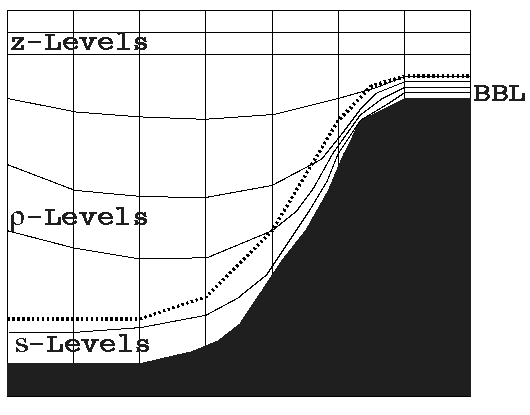
Recently, Dr. Song developed an adaptive vertical coordinate system for Navy's operational applications as well as for community research. The newly developed ocean model (Figure 1), and its predecessors SCRUM/ROMS, has been successfully applied to many coastal regions. 
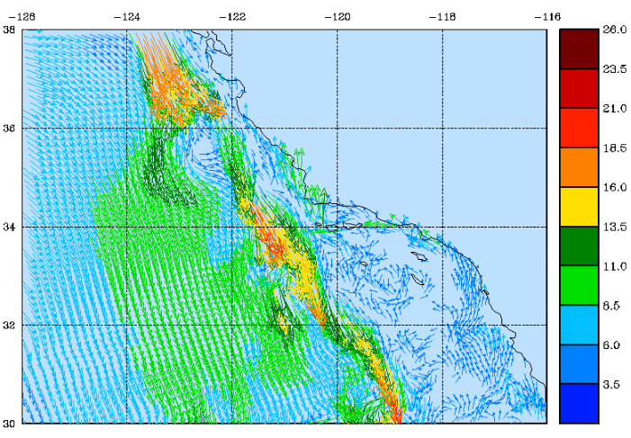
One of the applications at JPL is the Southern California Bight model (Figure 2) for studying coastal air-sea interaction using QuikSCAT winds (joint with Tim Liu and Wendy Tang). The model, forced by the QuikSCAT winds, successfully simulated the meandering California Current (southward), cyclonic circulations with the Bight, and the Davison near-shore Current (northward). This study demonstrated that spacebased observations could be used to advance coastal ocean studies.

model

Figure 1: Schematic of the newly developed adaptive vertical coordinate system for community ocean models with multiple application capabilities.

model

Figure 2: Ocean model results for the Southern California coastal ocean (3 km resolution): velocity field at σt=26.6 km/m3 shows the meandering southward California Current, the nearshore northward Davison Current, and the cyclonic circulation within the Bight.

Reference:
Song, Y. T., and D. Haidvogel, 1994: A semi-implicit primitive equation ocean circulation model using a generalized topography-following coordinate system. J. Comput. Phys., 115, 228-244.

Song, Y. T., 1998: A general pressure gradient formulation for ocean models. Part I: Scheme design and diagnostic analysis, Monthly Weather Review, 126, 3213-3230.

Song, Y. T., and D. Wright, 1998: A general pressure gradient formulation for ocean models. Part II: Energy, momentum, and bottom torque consistency, Monthly Weather Review, 126, 3231-3247.


                                              PRIVACY   |    IMAGE POLICY                  Webmaster: Xiaosu Xie